The Boeing Company hosts public hikes and tours through Santa Susana Field Laboratory areas contaminated with radiation and chemicals as part of its efforts to paint SSFL as ready parkland not needing full cleanup
• Hundreds of hikers and tour-goers made to sign waivers indemnifying Boeing & NASA for harm, with no opportunity to review waiver in advance
• Massive chemical and radiation contamination not yet cleaned up
• Radium-226, Plutonium-239/240, TCE, dioxins, PCBs, perchlorate pollution
• Rocketdyne official called area “Love Canal” decades ago
• Boeing says no press allowed on hikes, won’t divulge route or answer questions about safety but their own reports indicate high contamination in hiking areas
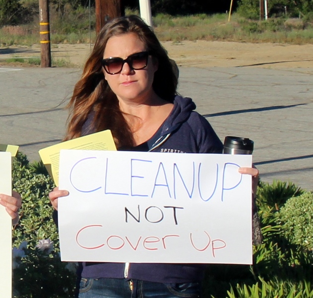
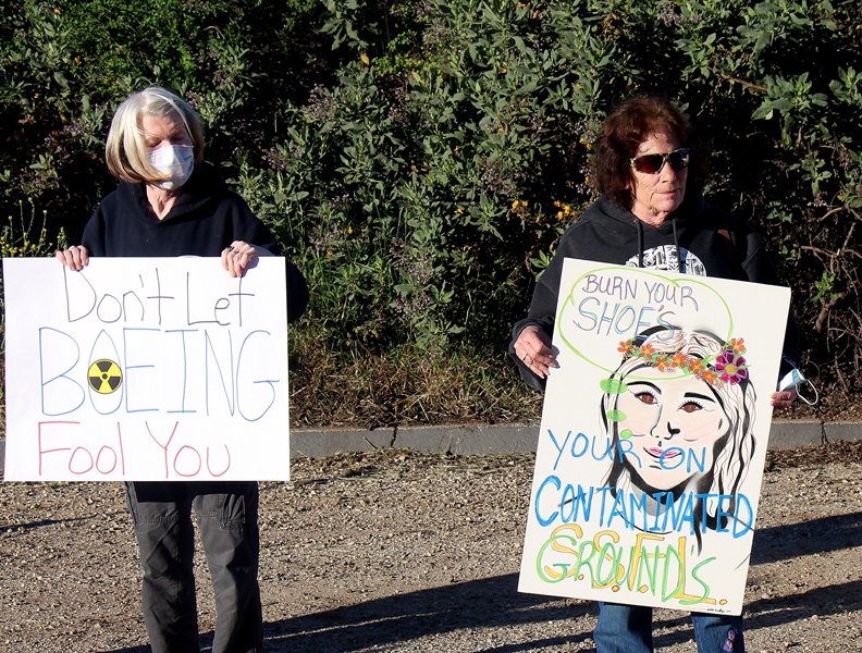
• Local residents hold April Earth Day demonstration to warn hikers about SSFL’s Southern Buffer Zone
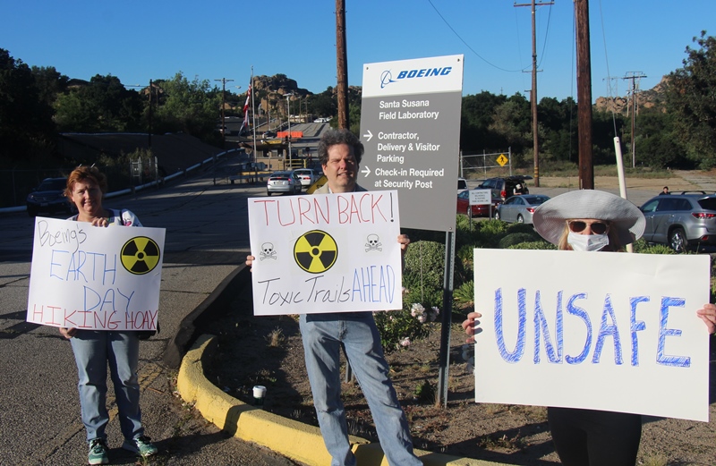
Eighteen demonstrators with vivid placards lined the roads into the Santa Susana Field Laboratory [SSFL] April 23. They were protesting lab owner Boeing’s “Nature Walk Earth Day Celebration” through the so-called 1,143-acre Southern Buffer Zone [SBZ] of the former Rocketdyne lab.
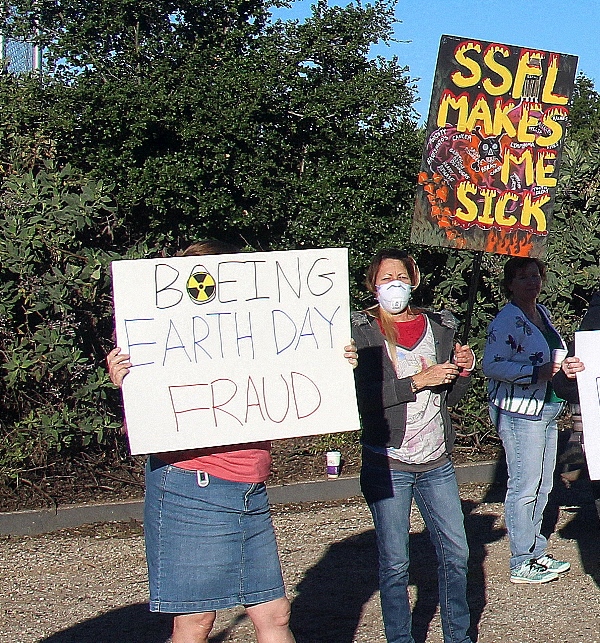 “BOEING EARTH DAY FRAUD” and “TURN BACK! Toxic Trails AHEAD” greeted startled hikers arriving in cars at the entrance to the 2,850-acre lab at the top of Woolsey Canyon in the Simi Hills. “SSFL MAKES ME SICK” and “Don’t Let BOEING Fool You” were not exactly what the trekkers expected judging from their shocked faces passing by.
Some may have been mystified by one sign that read “MELTDOWN ZONE AHEAD.” The former rocket testing and nuclear research complex has suffered at least three partial meltdowns since the 1950s, one worse than Three Mile Island in radiation spewed into the environment. Little did the walkers know that their hike would take them through much of the drainage of two confirmed nuclear-contaminated areas that are the subject of a decades-long cleanup costing hundreds of millions of dollars.
SSFL visitors would also get to trundle Area I of the lab and bird watch downslope of where massive rocket test stands stood and at least 30,000 rocket engine tests took place, leaving a toxic stew of deadly goo behind, still not cleaned up.
In doing so, hikers literally walked into Boeing’s efforts to greenwash their heavily contaminated site, which would save the aerospace giant millions in cleanup costs as EnviroReporter.com exposed in Boeing’s Meltdown Makeover in December 2012. The greenwashing campaign, instead of being shelved after its exposure, has grown to the point that it is now exposing people to places that need extensive cleanup.
EnviroReporter.com has uncovered information that suggests that the SBZ has highly contaminated soil, water and air vapor. Massive amounts of radiation and chemicals still plague parts of the SBZ including some that hikers have easy access to. Hike guides are responsible for where the amblers can go and are under the direction of Boeing.
While Boeing and the state Department of Toxic Substances Control [DTSC] are still testing and characterizing the SBZ for chemicals and radionuclides, they are apparently comfortable allowing hikes through the area – but on one condition: hikers must sign a waiver indemnifying Boeing and NASA from any future legal action over possible damage or death from being on the site.
The waiver does not give much information about SSFL’s nuclear history or its harmful contaminants, stating only that “…Santa Susana is an industrial facility undergoing closure and remediation activities…” The agreement not only enjoins any hikers from ever suing, it prevents their heirs from doing so as well, stating:
On behalf of myself, my heirs, successors, and assigns, I agree to release, discharge, indemnify and hold NASA and Boeing, its officers, directors, agents, insurers, employees, successors, and assigns (Boeing Parties), harmless from any and all claims, damages, demands, causes of action, liabilities, losses, expenses, or costs, including without limitation attorneys’ fees, of any kind or nature, foreseen or unforeseen, known or unknown, arising out of or in connection with my time spent at the Santa Susana property, including without limitation injuries (including death) to the undersigned and for loss of or damage to any property of the undersigned.
At the same time, the waiver also gives Boeing the rights to photograph and videotape hikers for use in any way Boeing or anyone Boeing authorizes sees fit, including using their pictures in glossy brochures touting the lab as a safe nature preserve. Boeing is already advertising its SSFL hikes by using a photograph of a female hiker walking with a child. The photo is unsettling to anyone who knows much about the contaminants found at SSFL, as many of its hazardous substances pose a greater health risk to women and children. The agreement states:
I hereby irrevocably give and grant to NASA and the Boeing Parties, all rights, title and interest in and to the photographs, audio recordings, video recordings and other information and materials identified herein obtained of me or from me. I acknowledge that my participation is voluntary and no consideration is required to give this release full force and effect.
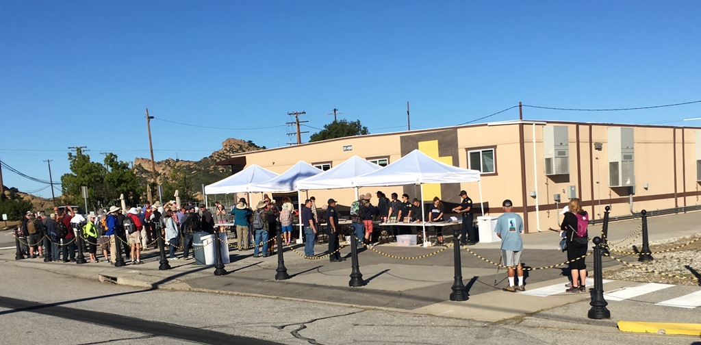
All of this was news to the trekkers since they were only given the waiver once inside SSFL gates under the watchful eyes of guards at the check-in area. EnviroReporter.com obtained the waiver on April 23 from protesters who managed to enter the property and flyer hikers’ cars in the parking lot.
Click here to read Boeing’s April 23 waiver or “Release of Liability and Indemnification Agreement.”
“Boeing won’t tell you that it is using you as part of its plan to evade cleaning up SSFL,” read the protest flyer from the Rocketdyne Cleanup Coalition. “The ‘nature walk’ you are taking is part of a campaign Boeing launched in 2012 to convince the public that the site is safe and doesn’t need much remediation.”
But it was too late for the oblivious nature lovers. The trekkers were only able to read the waiver and see the protesters’ warnings after they had driven all the way up the hill to SSFL on an early Saturday morning, and none seemed inclined to turn back. Boeing did not provide the waiver to hikers prior to their arrival, which would have been easy to do as hikers register and receive a confirmation from Boeing via email. The waiver is not available online.
EnviroReporter.com applied to go on the hike but was denied access to do it with fellow walkers. In the same breath, this reporter was offered an individual visit but then repeatedly refused confirmation of the hiking route.
“Thank you for your email and your interest in taking a nature walk and bus tour at the Santa Susana Field Laboratory,” wrote Kamara Noelle Sams, Environmental Community Relations representative for Boeing, on April 22. “For the enjoyment and privacy of our guests, our policy is to refrain from having media representatives and/or journalists present at community tours. We’d be happy to schedule a visit for you.”
Another reporter at the protest had also been told the same thing. Doubly disturbing is that repeated media requests attempting to confirm the hike’s route have been denied not only by Boeing but also by one of its most prominent hike guides and Boeing ally John C. Luker III. “I would prefer that you do not quote me or contact me in the future,” Luker wrote May 18 in response to our media request confirming the walk’s directions. “You’re [sic] portraits of me are something less than accurate or truthful.”
Odd that Luker would question our veracity and then not confirm the exact hiking route. Luker says on his Facebook page that he has personally led 1,000 people through SSFL and the SBZ. Surely he and Sams know the way the hikers are taking – and they should know the numbers on the high radiation, volatile organic compounds, heavy metals, PCBs and dioxins in the Southern Buffer Zone that EnviroReporter.com has found. Because it’s Boeing’s own data.
Since beginning to report on SSFL in 1998, this reporter has seen many tricks and schemes to co-opt, fool, insult and intimidate that part of the public who objects to destruction of the environment, property and human health caused by SSFL’s contamination. EnviroReporter.com has repeatedly exposed this over the years and in 2012’s Boeing’s Meltdown Makeover and 2014’s China Syndrome Town investigative series.
These hikes through the SBZ are an egregious example of this outrageous code of misconduct breaking new contaminated ground, literally. To any normal person, a new place to hike in the Simi Hills that has historic sites would seem very inviting. The only obvious dangers would be rattlesnakes and that hot zone of heat that bakes SSFL for much of the year.
Those people who are unwittingly taking these excursions have been induced to give up their rights to protect themselves and their families. They’ve also become dupes to convince more folks to fall for the same gooey hogwash whether they had planned to or not.
Keep On Toxic Trekking
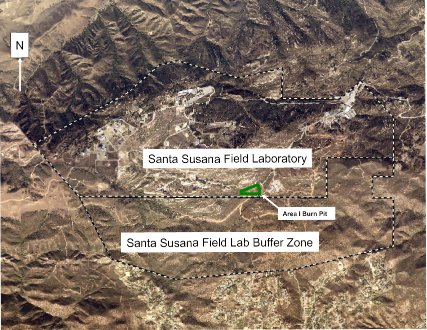
So where did the hikers get to kick up the possibly toxic dust getting all over their boots and pants before trailing it into their vehicles and homes after their jaunt? It’s most likely that the ramblers either walked or were bused through SSFL Area I to the SBZ and hiked from east to west and back. Either direction, they would have been afforded an up close and personal look at the SBZ’s pollution, except that the hike leaders’ greenwashing script probably emphasized bird and reptile watching with a strong dose of SSFL’s space history (albeit without mention of the lab’s Nazi-related origins.)
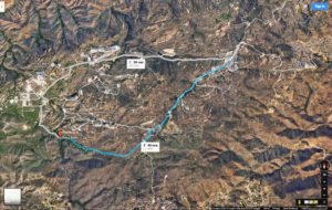
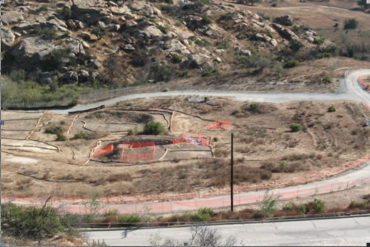
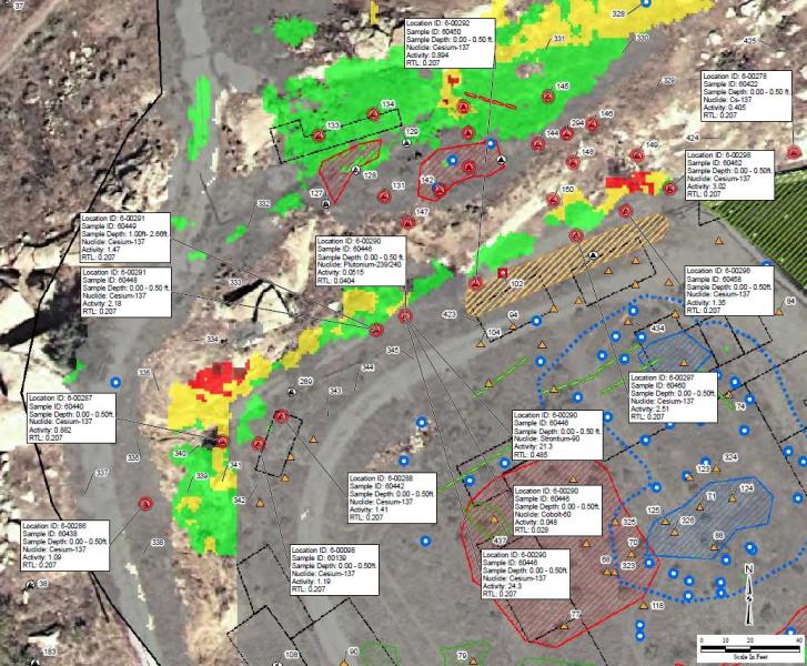
There is only one main fire road from east to west in the 1,140-acre SBZ which is about 2.8 miles long at its greatest and about a half to three quarters of a mile wide. It’s called Coca Avenue and it traverses through a large area Boeing has mapped in 2013 that’s called the “Burn Pit Chemical Use Area Cluster 1” or “Burn Pit CC 1”.
This Chemical Cluster is mostly in Area I and oozes over into the SBZ. Using Boeing’s map for scale, EnviroReporter.com estimates that the hikers trek through or near the Burn Pit CC 1, twice, as part of their nearly five mile nature trip. The enclosed map shows this likely route as it is the only way to walk the SBZ from the Area I check-in and its five miles roundtrip. Again, Boeing refused our repeated requests to confirm the route.
Even as Boeing’s greenwashing guides lead unsuspecting hikers near the Burn Pit CC 1, the company itself said in this December 2013 report that to judge the extent of surface water migration of the burn pit, “It is recommended that soil samples be collected to characterize dioxins and furans, cyanide, metals, PCBs, pesticides, Perchlorate, and SVOCs in the drainage channels down gradient of the western side of Area I Burn Pit RFI [Resource Conservation and Recovery Act Facility Investigation] Site. Similarly, it is recommended that soil sample be collected to characterize mercury, dioxins and furans, cyanide, metals, PCBs, pesticides, energetics, and SVOCs in the drainage channels down gradient of the eastern side of Area I Burn Pit RFI Site.”
The disconnect between the need to test for such an extensive and exotic brew of chemicals while at the same time taking people on guided tours near the impacted areas does not seem to have been made by Boeing or DTSC. How can Boeing and DTSC be sure that it’s already safe to let the public, albeit vetted and rights waived, wander through this zone with hot Santa Ana winds whipping up possibly impacted dust when there is so much more testing and cleanup to be done? Of course, another interpretation might be: if the place is already safe enough to hike, why is there any testing or cleanup at all? That is, of course, the position that Boeing and its allies are pushing and, per its greenwashing plan, a reason for holding the hikes and tours in the first place.
Hiking the Hot Zone
Chemicals aren’t the only contaminants plaguing the Area I/SBZ Burn Pit area. Radiation in the form of radium-226 and cesium-137 was found at high levels in the Burn Pit years ago and still hasn’t been removed. Sizzling readings of nearly ten times background have been detected in the pit near the hikers’ path and part of the same Chemical Cluster.
Prior to an unexpected bonanza of information revealed to EnviroReporter.com in March, Boeing and DTSC were not forthcoming with the most current radiation numbers, but judging from a January 13, 2015 Boeing report on the Area I Burn Pit, they aren’t good. It is especially disconcerting figuring in the vastly higher than background “soil characterization levels” (SCLs) Boeing that uses.
“The radioisotopes requiring further characterization are lead‐210, radium‐226, and uranium‐238,” the report read. “These chemicals and isotopes were detected at concentrations exceeding their respective soil characterization levels (SCLs), and the lateral and/or vertical extents of the chemicals and isotopes have not been defined.”
Two pages later, the report said that there were actually more radionuclides exceeding their SCLs but doesn’t recommend further characterization of them. “Radioisotope sampling was completed at or near each location where there had previously been exceedances of the SCLs and also to laterally and vertically bound [sic] those locations. The sampling from the First Iteration RAD WP successfully bound [sic] concentrations of cesium‐137, polonium‐210, thorium‐230, thorium‐232, uranium‐233/234, and uranium‐235/236 above SCLs.”
Not only were these six dangerous radionuclides left off of any further testing despite testing higher than normal, radionuclides Boeing tests for are evaluated through these SCLs that are much higher than background levels. Both NASA and the Department of Energy have a pact with DTSC to clean up their radiation and chemical contamination to background. That way, the panoply of lethal manmade radionuclides that have made nuclear Area IV’s soil so hot will be properly remediated and trucked away to a licensed radiation dump.
Not so for Boeing. Many of their soil characterization levels don’t even come close to the actual background of the radionuclides as determined by a 2012 $41.5 million study and assay of Area IV’s hot dirt. The Boeing SCL for uranium-233/234 is over double its actual background value.
Boeing’s SCL for plutonium-239/240, one of the most fearsome radionuclides man has made, is over 181 times its actual background. Neptunium-239 SCL is an out of this world 14,600 times its actual background at SSFL. DTSC quietly approved the SCLs in a March 6, 2014 letter to Boeing.
“They would have to walk through the Area I Burn Pit to get to the buffer zone, otherwise they would have to go through Area III and that’s way out of the way,” says William Preston Bowling, founder of the Los Angeles-based Aerospace Contamination Museum of Education. Bowling has been a leading Rocketdyne cleanup activist for over a decade.
“Radium was found in the Area I Burn Pit and never remediated,” Bowling says. “Just think, all those unsuspected hikers who signed their lives away, literally with the waiver Boeing provided as a requirement, could be exposed to that with each gust of wind. The Southern Buffer Zone should not be used for recreational hiking until properly remediated.”
Radium-226 is the longest-lived isotope of radium with a half-life of 1,600 years. Boeing found it radiating in the Burn Pit chemical cluster in nine areas with measurements of 1.7 to 9.6 times background. Or so they said.
That’s all the information EnviroReporter.com believed to be available – until May 2016 when we found that radium-226 was actually as high as 144.2 times background according to Boeing’s own numbers. Prior to the May toxic treasure trove, we looked back in time for any pertinent information on Los Angeles’ hottest hiking spot and the burn pit. There was enough of it to raise the alarm on the reckless notion of hiking through the area prior to full remediation.
Los Angeles’ Love Canal
Decades before the Area I Burn Pit became a hiking destination and departure point into the Southern Buffer Zone, it was so contaminated that a Rocketdyne employee called it Rocketdyne’s Love Canal in a memorandum to the company. The report by Norma S. Fujikawa was entitled The Leachable Legacy – SSFL Burnpit dated July 31, 1980.
Unlike the more infamous Sodium Burn Pit in nuclear Area IV, the Area I Burn Pit has not been totally excavated even 36 years after this shocking report was published.
The report describes the three to five acre site as being between Components Test Laboratories III and V and “adjacent to drainage channel to Bell Canyon Estates” which since 1961 had “over 500,000 gallons of hazardous wastes ‘disposed of’ there.” The hazardous waste identified in the pit was described as “ignitable, corrosive, reactive, extraction procedure toxic, acute hazardous, toxic.”
Fujikawa’s report submitted two recommendations based on its findings including “Rocketdyne may have to excavate.” The second suggestion was “Rocketdyne may request ‘grid’ sampling to prevent ‘Love Canal’ charges.”
Love Canal was a neighborhood in Niagara Falls, New York that became infamous in the mid-1970s for the 21,000 tons of toxic waste dumped there by the Hooker Chemical Company, which is now part of the Occidental Petroleum Corporation. The case was so sensational that it was one of the two sites that in large part led to the federal Superfund cleanup law, formally known as the Comprehensive Environmental Response Compensation and Liability Act, or CERCLA.
According to an internal Rocketdyne memo dated September 8, 1958, SSFL fire Capt. A.W. Miller’s message to Chief O.C. Ledbetter showed the reasoning for creating what Miller called a “Burn Pit for the disposal of dangerous materials.”
“Several months ago, while in the Inspection Office, the writer [Miller] had a large earthen pit constructed near the west boundary of the PFL [Propulsion Field Laboratory] just below CTL III,” Miller wrote. “This was, and has since been, used to dispose of dangerous chemicals, fuels, oxidizers, explosives, etc. These are burned with quantities of ordinary contaminated fuels. This procedure eliminated the costly method in use at that time, of trucking them from the facility and dumping in the ocean, or by other complicated ways of disposal requiring permits from various officials, agencies, etc.”
The so-called “Area I Thermal Treatment Facility” was closed by June 1991, a full 11 years after Fujikawa warned of potential “Love Canal charges.” By that time, the “facility,” which actually consisted of several pits dug into the dirt above Bell Canyon, had been in operation for 33 years with most of the airborne goo blowing on the predominantly northwest winds into the Southern Buffer Zone, Bell Canyon and the western San Fernando Valley.
The Department of Toxic Substances Control finally addressed remediation of the Burn Pit in July 2006. “DTSC is requiring the Boeing Company (Boeing) to dig up and remove an estimated 3,800 to 6,500 cubic yards of soil containing elevated dioxins and chromium at the former Burn Pit located in Area I (please see maps on the next two pages) of the Santa Susana Field Laboratory (SSFL),” read a DTSC fact sheet released to the public. “This work will reduce potential migration of dioxins, chromium and other chemicals from the Area I Burn Pit.”
Yet just a month later, DTSC reversed itself, abruptly cancelling a public meeting about the astonishing new site discovery. “DTSC has cancelled the public hearing on the Interim Measures Work Plan scheduled for Thursday, August 31, 2006,” the department announced with no explanation. “We have also cancelled the public comment period for this proposed document.”
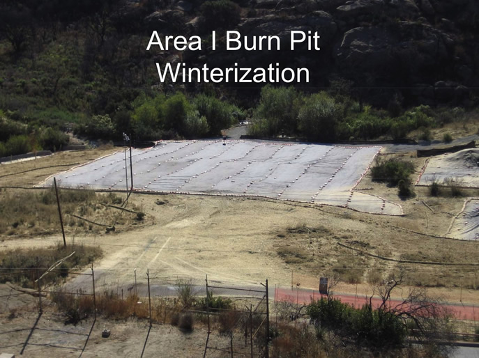
“There was a big controversy over this” says Bowling. “They found the radium [in the Area I Burn Pit], then they hired [former California Department of Public Health radiation expert] Jerry Hensley to come in to figure out this ‘strange’ occurrence, then he found Cesium-137 and they fired him. Then it was “Winterized” covered with tarps and nothing happened since.”
“There were no interim measures or clean ups, just the yearly “Winterization” of replacing tarps over the areas of concern,” says Bowling. “It was slated for a cleanup and then they found rads and halted everything.”
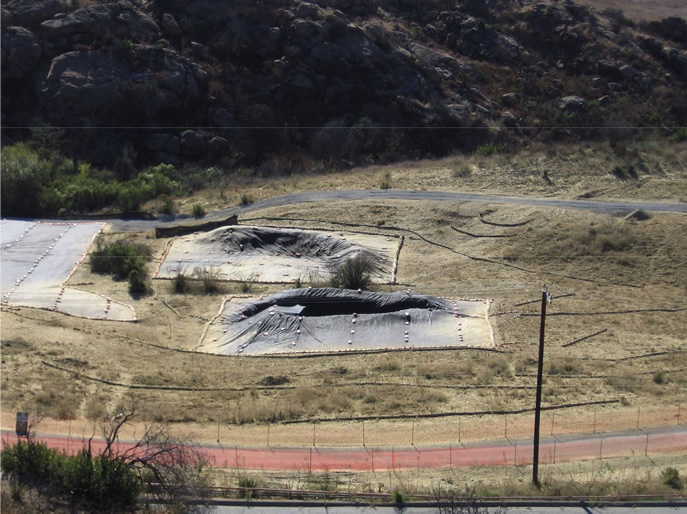
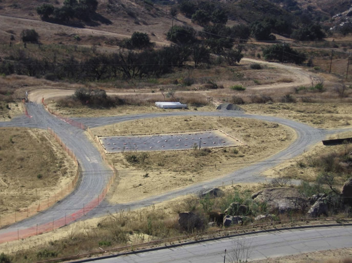
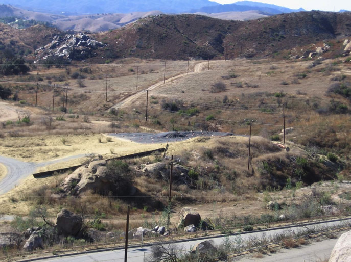
Nothing appears to have happened ever since except for the occasional swarm of clueless dupes trudging by taking in ‘nature.’ Indeed eight large areas covered with tarps are visible on a 2016 Google map of the area. Then a small, no doubt inadvertent, development broke the floodgates of data wide open.
Goo Breakthrough
After years of not being able to unearth any recent Boeing radiation and chemical tests of the Area I Burn Pit online, EnviroReporter.com asked DTSC if there was any more data on it besides what scant information we had unearthed. A May 13, 2016 message from the embattled department delivered that answer and, amazingly, its website now has all sorts of previously unreported material on it.
“Additional work has been conducted as part of the Data Gap process in Subarea 1B Southwest,” wrote DTSC public participation specialist Marcia Rubin May 13. Rubin included a link to this hoard of data on the Area I Burn Pit. “The results from the most recent (Data Gap) sampling will be included in the upcoming Subarea 1B Southwest data summary report.”
Appendix D of this September 2009 report prepared for Boeing by environmental and engineering consultants CH2M Hill laid out in clear detail the magnitude of contamination in the SBZ Area I Burn Pit. Out of all the astonishing numbers found by EnviroReporter.com in this report, it was the one on the cover sheet that was the most amazing: 2009.
Boeing should have known exactly what’s in the burn pit’s water, soil and soil vapor for at least the last seven years. But in 2013, without this goo being cleaned up, it chose to open these tainted lands to unwary hikers looking for new vistas. Boeing’s own report spells out in stark detail just how contaminated the Area I Burn Pit is. The dirt road trail through the burn pit is also contaminated.
Either Boeing is so incompetent and clueless to the significance of its own findings, a scenario that begs credulity considering it is Boeing, or it has chosen to ignore its own data. The result is that instead of being given a rundown of the radiation and chemicals visitors will be ambling through in the burn pit, they are given snazzy folding pocket guides for the plants, animals and birds that can be found in the Southern Buffer Zone and all over SSFL.
Appendix D could serve as a guide too, showing astounding levels of some of the most lethal substances on Earth. It lays out the birds and animals that the poison is harming and the threats to adults, children and “future recreators.” The problem is that the future is now and Boeing has opened the burn pit path and the rest of SBZ before it has remediated it.
Thanks to the $41.5 million testing of adjacent nuclear Area IV by the US Environmental Protection Agency (EPA) in 2012, it’s possible to make sense of the Area I Burn Pit numbers. Besides finding huge amounts of contamination as reported in 2012’s Radiation Readings Soar at Rocketdyne, the Area IV investigation produced a set of “background threshold values” (BTVs) for radiation and chemical background and contamination assessment.
The 2012 Area IV assessment was part of the “Agreements on Consent” (AOC) between DTSC and the Department of Energy (DOE), which operated in Area IV where three partial nuclear meltdowns took place, to remediate the land to background levels of contaminants. DTSC has the same AOC with NASA for its part of the polluted lab. Boeing is not bound by the AOCs.
It’s the Pits
According to Appendix D, the highest level of 2,3,7,8-TCDD in the burn pit was 2,684.4 times its BTV. This is the most potent form of dioxin. It was used in Agent Orange and is carcinogenic according to the International Agency for Research on Cancer.
The California Highway Patrol considers toxic substances, including radiation and chemicals, three times their respective BTVs or more as necessitating a Hazardous Material incident. The burn pit dioxin reading was 895 times the CHP’s Haz Mat trigger, surely a first in hiking trails in Southern California.
Radiation readings in the Area I Burn Pit top out at shocking levels. Bismuth-214 came in at 67.5 times its BTV with lead-214 topping off at 65.5 times its background. Fearsome radium-226 hit 144.2 times its BTV and perhaps the most potent radioactive substance man has ever created, plutonium 239/240, glowed at 5.7 times its background. According to “Plutonium: Deadly Gold of the Nuclear Age” by the International Physicians for the Prevention of Nuclear War and the Institute for Energy, amounts of Pu-239/240 as small as a millionth of an ounce could cause lung cancer.
In all, EnviroReporter.com found 17 dangerous radionuclides tipping the beam over their respective backgrounds including cesium-137 and strontium-90. Never in the history of reporting on SSFL has so much radiation at such high levels been reported being found outside of nuclear Area IV. It is not only unprecedented, it proves that nuclear material was dumped and burned in Area I at such high levels that it is still CHP Haz Mat hot.
Chemicals keep the contamination stew cooking in the burn pit soil and soil vapor. The dirt’s unremediated “Chemicals of Ecological Concern” include perchlorate, cyanides, DDT, dioxins and furans. “[B]enzo(a)pyrene and dioxins contribute to unacceptable human health risk through exposure to soil (residential and recreational receptors),” the report said.
Perhaps most astonishingly, Boeing’s Appendix D revealed that “Several chemicals significantly contribute to the estimated human risks, both incremental lifetime cancer risk (ILCR) and noncancer HI, and to ecological risks within the Group 1B Reporting Area.” Getting more specific, the study said “Aroclor 1254, dioxins/furans, benzo(a)pyrene, and arsenic were identified as COCs [Chemicals of Concern] for direct contact with soil by future recreationists.”
In other words, that dust hikers might be getting on their boots and clothes and breathing in tromping along with fellow SSFL explorers might harm them. It is unlikely any of these people know that direct contact with the burn pits dirt and dust could have such dire implications.
“Recreational receptors” out for a stroll in the hot zone with Boeing-picked hiking guides aren’t the only creatures to be affected by the SBZ’s galaxy of goo. Critters are getting it, big and small, above and below ground and in the air.
“Aroclor 1254, Aroclor 1260, and dioxins/furans contribute to unacceptable risk to the hermit thrush and deer mouse,” the study said for both soil and soil vapor. That’s in addition to the more famous gases fuming out belowground beasts. “1,1-DCE and TCE in soil vapor contribute to unacceptable ecological risk to burrowing receptors.”
Not surprisingly, you won’t find any of this in Boeing’s lux pocket guides showing all the healthy looking critters that supposedly reside in the SBZ free from harm. You will find this, though: “As a result of high-technology testing and research, chemicals seeped into the soil and groundwater. Boeing is committed to a comprehensive and protective cleanup that protects the ecosystem and preserves the site as open space for future generations.”
The “high-technology testing” at the Area I Burn Pit consisted of setting the most virulent toxic waste on fire and watching the plumes of goo drift offsite. The “comprehensive and protective cleanup” hasn’t yet dug out the burn pit near hikers, courtesy of Boeing.
The EPA relies on this dose-based formula that derives hard numbers on each chemical and radionuclide’s concentration that would break individual thresholds, which are usually close to the substances’ BTVs. These near background numbers are called the Preliminary Remediation Goals (PRGs). “All contamination exceeding cleanup levels will be removed such that the site-wide carcinogenic risk will be less than 1 x 10(-6) [one in a million],” according to an October 17, 2000 DTSC report. This goal is used by DTSC, Cal-EPA and the federal EPA.
Boeing’s Appendix D shows that the burn pit is so contaminated that its “Human Health Risk Estimate” has drilled down on its toxicity by soil, water and vapor from the volatile organic compounds (VOCs) that plague the former Rocketdyne site. The soil alone increases the chance of the “Future Adult Recreator” getting cancer by eight times. For the “Future Child Recreator” it goes up by ten times.
This is doubly appalling, literally, when considering the soil human health risk of the Bowl Test Stand area that hikers pass is half the adult risk even though it was used for thousands of rocket tests over decades.
Upon entering the Area I Burn Pit, hikers could be fooled into thinking that the areas they see covered by large black tarps are the extent of the contamination. Boeing’s own detailed maps and figures in Appendix D show how the road through the burn pit to the SBZ is in a “chemical use area” which is alarming enough. EnviroReporter.com‘s analysis of these multiple maps finds that the highest VOC and dioxins reading were in the middle of the road, the highest PCBs on the side of the road and the highest heavy metals all over the road.
Feel the Burn
The contamination problem in the Southern Buffer Zone could be even larger than Boeing’s estimations according to the DTSC in its comments in Boeing’s December 2013 report: “Many of the outlying soil samples along the southern margin of the Area 1 Burn Pit site boundary exhibit detectable concentrations of TPH, metals, and dioxins. Additional data gap sampling in this area should be proposed to firmly establish the southern extent of releases for refined definition of the CMS areas. The reported detections and their associated contamination patterns also suggest that the southern boundary of the Area 1 Burn Pit should be extended southward, perhaps as far as the Group 10 boundary and beyond. Downstream drainage samples should be a particular focus of complete Area 1 extent delineation.”
That’s a lot of goo. And it’s not just prevalent in the Area I Burn Pit Chemical Cluster because it moves downhill. Subarea 10 below the burn pit cluster has dioxins and furans at three surface soil locations that exceed their Soil Characterization Levels. Toxic heavy metals at 27 other places in the SBZ also exceed their SCLs.
An August 1, 2013 DTSC PowerPoint shows Subarea 10 as having four confirmed “Chemical Use Area” [CUA] sites which include all the main drainages through the SBZ. CUA 2 is the Central Drainage which is, not surprisingly, in the middle of the hiking zone. The drainage has “Polynuclear aromatic hydrocarbons (PAHs), polychlorinated biphenyls (PCBs) dioxins/furans polychlorinated biphenyls (PCBs), dioxins/furans, pesticides, metals, and cyanides exceed SCLs” according to DTSC.
Hot Springs
Walking farther west through the Southern Buffer Zone towards Area IV’s drainage entails hiking along Coca Avenue leads into Subarea 5/9 South Unaffiliated Area before running into the southern border of the lab proper itself. Boeing’s June 2015 Subarea 5/9 South report makes the area seem clean and good to go as far as “recreators” go.
“No Further Action (NFA) for all media within this subarea,” the report said at the beginning before reiterating itself at the end. “For the reasons described above, surface water in the southwest drainage of Boeing RFI Subarea 5/9 South is not estimated to pose unacceptable risks to future recreators.”
The meat of the report seems to have told a very different story. Boeing identified 30 Corrective Measures Study (CMS) areas “to address estimated risks associated with potential exposure of human receptors (hypothetical suburban resident and future recreator).” These include soil and vapor tests and “18 CMS areas and 21 CMS locations have been identified to address potential migration of chemicals from the vadose zone to groundwater.”
“The recommended CMS areas for soil, soil vapor, and vadose zone bedrock cover approximately 11 acres in Boeing RFI Subarea 5/9 South and are primarily driven by the following chemical groups: volatile organic compounds (VOCs), semi volatile organic compounds (SVOCs), total petroleum hydrocarbons, polychlorinated biphenyls, pesticides, herbicides, dioxins and furans, inorganics, and metals,” the Boeing report continued. “These areas will be evaluated further for corrective action in forthcoming CMS Reports.”
The irony is lethal. Before and after this litany of goo found by Boeing is Boeing’s determination that no further action is required and it’s safe for recreators but they’ll evaluate it for upcoming reports anyway. This is contradictory nonsense and bad science at its boldest.
But it gets worse. Even though the media wasn’t allowed on the Southern Buffer Zone hike, it wasn’t impossible to glean the natural turnaround point for a five-mile round-trip hike. The “nature walk” likely began at the Boeing ‘sign this waiver’ registration point in Area I before heading southwest down the Area I Road past the Area I Burn Pits and into the SBZ.
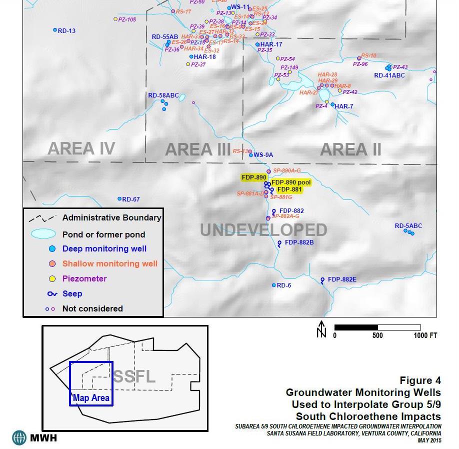
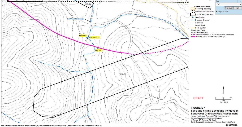
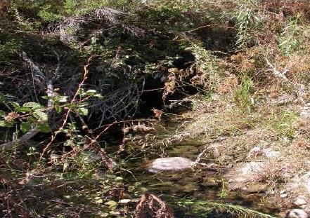
The most likely SBZ hiking route brings folks to a beautiful grove of oak trees with two gurgling springs about 100 feet apart and with one spring by the road along with a year-round pool. Boeing says it is committed to ensuring that SSFL becomes open space, making it likely that future visitors would see the springs as a perfect place to water the dogs, refill the water bottles with purifying filters and just soak in the cool water. That might not be the best idea, though, no matter how inviting in the hot zone where temperatures can top 100 Fahrenheit. All three water sources have showed signs of serious chemical and radiological contamination.
The springs, or seeps, are designated in the Boeing report as FDP-881 and FDP-890 with a separate unit designation for FDP-890’s adjacent pool. As far as EnviroReporter.com can determine through photographs and satellite imagery, there are on no caution signs like those found on the other side of Area IV downslope in Brandeis-Bardin.
Both SBZ springs and the pool exceed California’s Maximum Contaminant Level (MCL) for trans-1,2-Dichloroethene (trans-DCE) in drinking water according to Boeing’s June 2015 report. Trans-DCE was used at SSFL for precision electronics and metal cleaning. Related compound cis-1,2-Dichloroethene was found at 33.3 times its MCL in FDP-881 and 35 times the limit in FDP-990.
Both compounds are byproducts of carcinogenic vinyl chloride which in FDP-881, the seep by the road, was tested at 58 percent higher than its MCL. “Some people who use water containing vinyl chloride in excess of the MCL over many years may have an increased risk of getting cancer,” says the July 16, 2015 California Regulations Related to Drinking Water[LINK DISABLED].
Trichloroethene (aka trichloroethylene or TCE), is gurgling out of both springs and the pool. The rocket engine cleaning solvent that has seriously contaminated SSFL’s groundwater topped out at 70.6 times its MCL in FDP-890 according to Boeing’s own numbers.
“Some people who use water containing trichloroethylene in excess of the MCL over many years may experience liver problems and may have an increased risk of getting cancer,” says the state regulations. There isn’t any warning given to hikers that EnviroReporter.com could uncover, either verbally or written, that informed ‘recreators’ of this risk.
Nor is there any mention of the alpha and beta radiation burbling out of FDP-881’s spring hard by the side of the hiking road. Alpha radiation, the most dangerous and rare kind, has clocked in at 3.1 times its MCL while usually-manmade beta radiation topped out at 9.5 times its MCL.
These huge radiation readings are reportable under the federal rules of the Clean Water Act. EnviroReporter.com could find no evidence that these high radiation readings were reported anywhere but in this report. The goo bubbling out of these SBZ seeps and pool make its way down into Bell Canyon Creek and the Los Angeles River, a protected waterway the focus of a billion dollar renovation.
Rocketdyne River
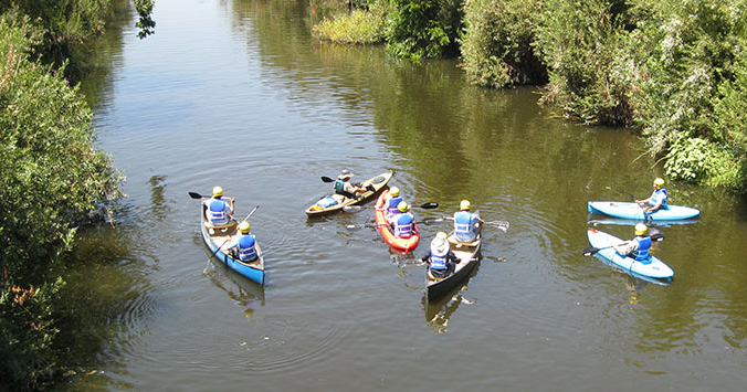
Los Angeles’ ability to reinvent itself is well known and is about to happen again. The Los Angeles City Council approved a $1.3 billion plan to restore the LA River June 29. When the 11-mile stretch of restoration is done, kayakers, waders and sports fishermen will have access to a beautiful waterway.
“I congratulate and thank the City Council for its unanimous approval of the plan to restore the Los Angeles River,” said Los Angeles Mayor Eric Garcetti in a statement. “Today’s vote is the result of more than a decade of hard work — and takes us another step forward in our effort to transform a waterway with a rich history, and great potential for our city’s future.”
There’s just one catch. The river’s headwaters are the Santa Susana Field Laboratory, itself draining though the Southern Buffer Zone. About 90 percent of the lab’s Area IV, site of partial meltdowns, radioactive fires and copious toxic dumping of radioactive wastes, drains down the SBZ into the LA River.
Friends of the Los Angeles River Lewis MacAdams, founder and main impetus for the waterway rejuvenation project with the Army Corps of Engineers, found this out in a 2012 visit to SSFL. “Speaking for myself, the headwaters of the L.A. River are a stinking cesspool visually,” MacAdams told EnviroReporter.com, “and can’t help but have negative implications for the river downstream.”
With $1.3 billion being spent to green the river, one would assume the planners would have looked to the headwaters to see if they see if there were any problems there. They apparently did not, even though kids will be splashing around in what might be called Rocketdyne River once the plan is complete. What EnviroReporter.com found in one telling December 2013 Boeing report was enough alone to confirm the threat the lab’s runoff from the SBZ’s burn pit drainage presents to the waterway.
The report suggests that the poisons in the Southern Buffer Zone could be greater in scope than previously known by Boeing. “Many of the outlying soil samples along the southern margin of the Area 1 Burn Pit site boundary exhibit detectable concentrations of TPH, metals, and dioxins,” the report said under its “Extent of Contamination” section. “Additional data gap sampling in this area should be proposed to firmly establish the southern extent of releases for refined definition of the CMS areas. The reported detections and their associated contamination patterns also suggest that the southern boundary of the Area 1 Burn Pit should be extended southward, perhaps as far as the Group 10 boundary and beyond. Downstream drainage samples should be a particular focus of complete Area 1 extent delineation.” [Our emphasis]
This report is from the same year that Boeing initiated its trots through the toxics for the easily fooled. Using the excellent maps in these reports, the likely hiking road goes through what’s called the Burn Pit Chemical Use Area Cluster for about 450 feet. That’s a lot of hikers kicking up a lot of dust before the place is even cleaned up in one of the most polluted places at SSFL.
To Tell the Truth
Why doesn’t Boeing get to it and just clean up the Area I Burn Pit and the SBZ before declaring it a nature walk zone? According the December 2013 Boeing report, it’s because environmental regulations are stopping them from doing so. “The feasibility of these moving forward with such measures is largely constrained by California Environmental Quality Act (CEQA) issues, and further progress on CEQA issues may need to be complete before such Interim Measures can be proposed.”
So, time to open up the place as an open space destination with free guided walks and free snazzy nature guides provided hikers sign on the dotted line to prevent them from suing over, say, walking through the Area IV Burn Pit for a quarter mile.
How does Boeing do it? How does this international titan pull these kinds of peculiar and devious sleights of hand to fight cleaning up SSFL to background like DOE and NASA are doing? How can a company put its shareholders’ assets at risk by courting lawsuits over inducing the public to recreate on land it knows is contaminated and still not cleaned up?
For 18 years on the SSFL story this reporter has seen all manner of gooey hooey. It began early writing for Los Angeles magazine, LA Weekly and the Ventura County Reporter and has lasted until now where Boeing refuses to confirm its Area I/Southern Buffer Zone hiking route.
In early 1998, Steve Lafflam, then Boeing/Rocketdyne’s division director for safety, health and environmental affairs, said the residents of Bell Canyon didn’t want the lab tap turned off because they enjoyed babbling Bell Creek with its walking trails, waterfalls and wildlife.
Fast forward to 2012 where EnviroReporter.com exposed an elaborate ‘greenwashing’ scheme to makeover SSFL’s negative image of meltdowns and gross pollution. Former Los Angeles Times environmental reporter Gary Polakovic’s scheme envisioned “third parties” to “add credibility and authenticity and blunt allegations of green-washing” and was to tout Boeing’s environmental stewardship of SSFL to “shift discussions from a site with a sordid past to one with potential.”
Gaming the Girl Scouts
Polakovic wasn’t done with his SSFL greenwashing duties in 2012. EnviroReporter.com obtained from fellow investigative journalist Joan Bien a May 2013 Santa Susana Field Laboratory Tip Sheet sent to her from Boeing’s Sams. Polakovic and Sams’ names were listed as contacts on the tip sheet, which had this disturbing entry under the “Springtime at Santa Susana” section:
“May 25 – Girl Scouts Honey Bee Badge Day. Girls from across the Los Angeles region will enjoy a nature hike, study honey bees and plant oak trees to earn merit badges.”
Polakovic had struck again. Girl Scouts in the hot zone would look good on future Boeing propaganda greenwashing the blighted lab. Young girls digging in SSFL’s dirt to plant oak trees would certainly paint SSFL in Girl Scout green. Polakovic’s PR gold was to be Girl Scout greenwashing one of the contaminated aerospace sites in the United States.
The plot did not sit well with Westlake mom Cindi Gortner, who was also at the April 23rd SSFL hiking protest with a sign saying “UNSAFE.” Gortner sent the local Girl Scouts’ Anne Marie Hand an email May 15 signaling her strong disapproval.
“As the mother of a Girl Scout and a former Girl Scout myself, I am further troubled by the misuse by Boeing of Girl Scouts in Boeing’s public relations efforts to portray the site as “safe enough for Girl Scouts” which aides their controversial effort to avoid a costly cleanup,” Gortner wrote. “I am sure you can imagine that parents could be quite upset if Girl Scouts did not provide them with the EPA information on SSFL’s nuclear and chemical contamination prior to allowing their children to visit the site. And frankly if I were to receive that information, I might question the judgment of Girl Scouts in planning such an activity. Children are more susceptible than adults to the effects of exposure to the nuclear and chemical contamination, and girls are even more susceptible than boys.”
EnviroReporter.com gave the Girl Scouts a call May 20, 2013 and was given a runaround by marketing director Kenya Yarbrough who blamed a “media frenzy” for endangering the girls therefore leading to the cancellation of the event. The only problem was that this reporter was the first (and likely only) to enquire about the Honey Bee Badge Day at SSFL and my questions certainly weren’t frenzied.
“We, uh, basically got some information about the grounds and it kind of stirred a controversy that may have led media to come out to event and we do not like to expose girls to controversy or media, a media frenzy based on the information we are not aware of but just don’t know about so we really wanted to educate ourselves on that so the event’s just been canceled, you know,” Yarbrough said. “I can’t tell you what the future would have been if things, everything, it’s just that we’re not, we are not about being at the center of a controversy. We’re not about the media using Girl Scouts as part of any controversy so there’s just been some concerns.”
Not once did Yarbrough express concern for the health of the Girl Scouts. Gortner however made it clear that the issue was not about exposing the girls to controversy; it was about exposing them to hazardous substances.
“I don’t have to tell you that our beloved Girl Scouts organization should not be used as a pawn in a clever media campaign by a polluter to avoid its cleanup operations,” Gortner said in her email to the Girl Scouts, “and the girls should not be exposed to toxic materials at a site recommended for Superfund status and which hasn’t been cleaned up.”
Greenwashing Bloopers
One of the ways Boeing is repurposing the lab is to truncate its name from the Santa Susana Field Laboratory to the more attractive sounding “Santa Susana.” This was done in the tip sheet announcing the doomed Girl Scouts visit and on the 2015 SSFL tour bus flyer.
EnviroReporter.com was ‘gifted’ a “Santa Susana 2014 Calendar” by Rocketdyne activist and Runkle Canyon Radiation Ranger “Wild Bill” Bowling. The April 2014 calendar photo of a beautiful moth caught our attention because it seemed to be missing some parts. Could Boeing have picked a mutated moth for its calendar thereby reinforcing the genetically destructive effects of radiation on all living things like the ones that live at “Santa Susana”?
We reached out for some answers to Dr. Andrei Sourakov, collections coordinator, McGuire Center for Lepidoptera & Biodiversity, Florida Museum of Natural History. Sourakov is one of the world’s leading moth and butterfly experts.
“I have a query about a photograph of a Ceanothus silk moth, (Hyalophora euryalus) that I found in a calendar (see attached photo I took of calendar),” this reporter wrote to Dr. Sourakov July 17, 2014. “It seems to me that the moth is missing a couple of legs, or at least appears to be (if “legs” is the appropriate appendage designation). Can you speculate if this moth appears to have a genetic mutation (ie deformation) to account for the missing legs?”
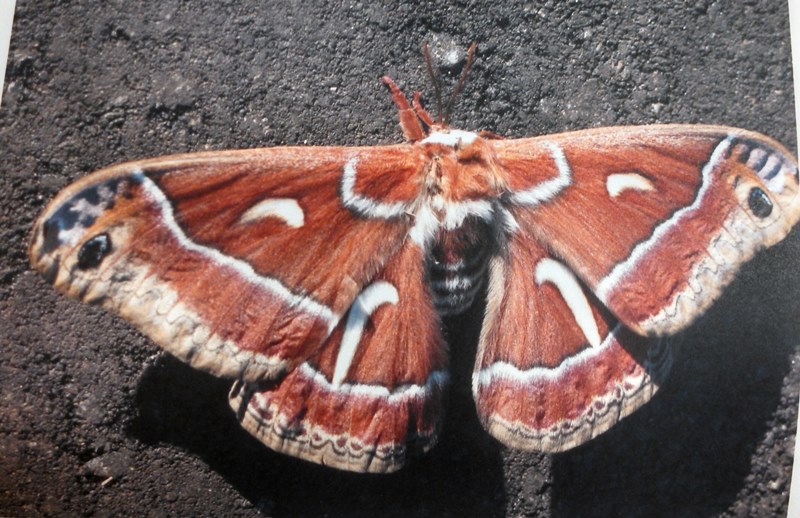
Indeed it did appear to Dr. Sourakov to be mutated. “Perhaps the legs are gynandromorphic, as in Fukushima butterflies (see attached)?” Dr. Sourakov responded referring to range of mutations seen in moths and butterflies in Japan since the ongoing triple meltdowns at Fukushima began over five years ago.
“Gynandromorphic” means an organism that is male on one side, female on the other. A 1995 landmark report by Sourakov and two others found a correlation from “nuclear pollution” resultant from the 1986 Chernobyl meltdown in Ukraine and dual-sexed butterflies. “The situation may reflect a high level of radiation-induced somatic mutations,” the University of Florida study said.
Of course, none of this information is going to matter to John Luker, who leads the SBZ hikes and calls himself “One of the lead activists trying to clean up and preserve the Santa Susana Field Lab for the future.”
In a May 10, 2014 email to Bowling, Luker mocked concerns about the SBZ. “No body [sic] ate the dirt. No body drank from the streams. No body got dirty. No body breathed anything bad. We walked the entire time on a dirt road.”
“My intent has been to show the public that this place is not a “Toxic Wasteland” as you have characterized the buffer zone, but rather, the resource it is,” Luker continued. “It’s working. More and more people are listening and making up their minds.”
When people listen to Luker, they never know what will come out of his mouth other than knowing it will be infused with braggadocio and inflammatory nonsense. “[I]f you get three Indians in a room you’re going to have a fight,” Luker said at a January 21, 2013 meeting about the proposed Rim of the Valley National Park with Gary Polakovic and Bill Bowling in the audience. “Pretty much I’ve seen that to be true.”
Luker continues to congratulate himself on being the hot zone hiking host as he bragged April 25 on Facebook. “Wow, Time flies. I think I’ve led the hike in the Southern Buffer Zone 7-8 times now. Over 1000 people have gone on my tours. I hope you all can make it on the next one. The place is amazing.”
Amazing indeed – that is, it is amazing that Boeing has implied since 2013 that SSFL’s Southern Buffer Zone is safe for hiking even though the reports EnviroReporter.com has analyzed indicate heavy contamination to which hikers may well be exposed.
Boeing also holds bus tours through the site, with two stops – the Alpha rocket engine test stand and the former Sodium Reactor Experiment [SRE] which partially melted down in 1959. “A shallow soil sample by the side of the road on the way to the SRE was sizzling with cesium-137 over a thousand times its background,” we reported May 6, 2012 in Radiation Readings Soar at Rocketdyne. That article showed just how contaminated land around the SRE was found to be by the EPA yet today it’s a tour destination.
Zappy Trails
Most folks find the call of the wild more compelling than the call to use caution when hiking or touring contaminated lands. After all, places like the Southern Buffer Zone are stunning in beauty. It’s no wonder much of SSFL was sacred to Native Americans long before Cold War warriors desecrated the air, water and land.
According to the US Nuclear Regulatory Commission, “ALARA is an acronym for “as low as (is) reasonably achievable,” which means making every reasonable effort to maintain exposures to ionizing radiation as far below the dose limits as practical, consistent with the purpose for which the licensed activity is undertaken.”
This reporter first heard the term and learned what it meant when on a site tour of SSFL in 1998 with lab representatives Steve Lafflam and Phil Rutherford. Before my Los Angeles magazine team and I were given a comprehensive tour, we watched a radiation safety film and were outfitted with radiation exposure badges. ALARA was the goal.
Eighteen years later and ALARA has gone out the window. Over a thousand people, some of them kids, are walking in a place that hasn’t been cleaned up completely and probably never will be. People are being sold on the beauty of the place and all the critters when Boeing’s own report shows that mice, deer and birds are taking a hammering from SSFL’s goo.
Boeing no longer goes by ALARA. Instead, it seems to be going for “ALAYCG” – As Low As You Can Go.
SEE AUGUST 6, 2016 PROTEST GALLERY INCLUDING POSSIBLE ANTIMONY PIPE DISCOVERY
25 Years of Award-Winning SSFL/Rocketdyne Reporting
1998 – 2023


I don’t live in your area, just stumbled across this today. (I wish I could tell you that the idea of this happening sounded absurd or impossible, but it’s more like a nuke-scaled version of what happens in my city)
One thing that concerns me about the way its reported is taking the liability waiver at face value. This seems like an obvious example of ‘fraudulent misrepresentation’ that would void that waiver.
Why have people sign it at all if it’s unenforceable? Well, because most of them will assume that they have signed away their rights to sue. You’re unintentionally doing them a favor by taking their legalese at face value.
I realize this is a few years old, but noticed the recent updates in the comments and I hope you get a notification or notice it. Important note: I’m not a lawyer, and I don’t live in your state. I’m not asking you to assume I’m an expert about contract law, just that you check with someone who is.
***
PS – The dude who says no one got dirty or breathed in any radioactive material on the hikes because it was just a bunch of people hiking on a dirt trail? WHAT? That is exactly the kind of thing that puts a ton of dust in the air (unless it’s wet enough to be muddy). I can’t even fathom what he’s telling himself here…
The concerned citizens of the Rocketdyne Cleanup Coalition sent us the following message. It is of particular interest to EnviroReporter.com as we exposed this issue in 2016 with Critics question safety of Boeing’s Santa Susana Field Lab hikes and Boeing SSFL Bus Tour Demonstration August 6 2016:
Dear SSFL Cleanup Supporter,
Are you tired of Boeing’s efforts to get out of cleaning up most of the pollution on its property at SSFL? Does it make you angry that, despite its own reports showing dangerously high contamination, Boeing states that SSFL poses no risk to health – and even hosts hikes and tours to convince others that it is safe?

If so, please join us this Saturday April 20 from 7:15 – 8:15 a.m. to protest Boeing’s “Earth Day” hike of SSFL, an event designed to minimize its nuclear and chemical contamination and persuade the public that SSFL doesn’t need much of a cleanup.
We will gather near the entrance to SSFL, near the water tower at the end of Woosley Canyon. Click here for a Google Earth map.
We will have protest signs or you can bring some of your own. We want to let Boeing know that it is NOT okay to use members of the public as propaganda for its anti-cleanup goals, and that it must clean up all of the contamination so that nearby communities – and hikers – are no longer at risk.
Please RSVP here or by replying to this email so we can estimate how many will participate. More information on Boeing’s cleanup and “green-washing” plans is below.
Sincerely,
Rocketdyne Cleanup Coalition
Background information – Green-Washing Rocketdyne
In 2012, we discovered that Boeing had hired a company called “Makeover Earth” to help change the narrative about SSFL and “shift discussions from a site with a sordid past to one with potential.” The idea was to push feel good stories about SSFL and what a nice open space park it will be. Boeing knew this wouldn’t be an easy sell – the plan even talks about finding “third party allies” that can “blunt allegations of green-washing.”
Part of Boeing’s green-washing plan has been to hold hiking and bus tours at SSFL, where it can boast about its achievements and greatly minimize how contaminated the site truly is. On one tour, a Boeing representative told attendees that after its cleanup, the site would be safe to hike once a week. Once a week? Think about that. If the site will only be safe to hike once a week, what does that mean for all of the residents who live nearby, 24-7? And why is anyone hiking there now, before cleanup has even begun?
Boeing’s PR blitz is especially disturbing given that its own cancer risk assessment reports show that in some parts of the property, as many as 96 in 100 people would get cancer if they lived there. Boeing wants to leave 98% of SSFL’s contamination on site permanently, where it will continue to migrate and threaten public health. That is unacceptable. Click here to learn more about Boeing’s greenwashing of SSFL, and join us on Saturday to tell Boeing to clean up, not cover up!
The Southern Buffer Zone (SBZ) is even more contaminated than previously reported by EnviroReporter.com according to a new report called the SSFL NASA Area I LOX and Area II Groundwater Monitoring Report Third Quarter 2016. In it, NASA reveals that the rocket-fuel associated, and extremely poisonous, NDMA had hit a new high in one of the SBZ’s monitoring wells near where the hikes pass.
“NDMA was detected above the Notification Level of 0.01 μg/L at a new maximum historical level of 0.013 μg/L at monitoring well RD-05B,” the November 2016 report says “NDMA has been detected at this location prior to the third quarter 2016 with a previous maximum detection of 0.0049 μg/L.”
That’s a 265.3% jump in NDMA from the previous high. It’s also over 18.6 times the EPA’s limit on the suspected human carcinogen in US drinking water. NDMA is highly toxic and targets the liver. It also moves through the environment quickly, can’t be filtered out with charcoal, and won’t evaporate. It is very nasty stuff.
“[T]rans-1,2-DCE was detected above the California MCL of 10 μg/L at new maximum historical level of 24 μg/L at SP-890C and SP-890G,” the report also says. “This detection was reported at a level more than twice the respective screening criteria and has been detected at these locations prior to the third quarter 2016 with previous maximum detections of 20 μg/L and 22 μg/L, respectively.”
Trans-1,2-DCE is colorless, highly flammable and smells bad. It’s used to make chemicals and solvents. Breathing high amounts can make you tired, drowsy and nauseous. “People who are most likely to be exposed live near landfills and hazardous waste sites that contain this chemical, work at factories where this chemical is made or used, work at 1,2-dichloroethene contaminated landfills, or work as firefighters,” says the Agency for Toxic Substances and Disease Registry. Add to that hikes through the Southern Buffer Zone.
Also add a new chemical found in the SBZ. “Isopropanol was detected for the first time at seep wells SP-881C, SP-890C, and SP-890G below the taste/odor threshold of 160,000 μg/L at an estimated concentration of 88 J μg/L (SP-890C and SP-890G) and concentration of 160 μg/L at SP-881C.”
Isopropanol is used in the production of acetone and as a solvent. It joins a host of other contaminants NASA reports just found in July in the SBZ: Trichloroethene (TCE), vinyl chloride, cis‐1,2‐Dichloroethene and n‐Nitrosodimethylamine all at validated analytical detections.
Hikers, birders and tour attendees in Boeing’s Southern Buffer Zone beware. You aren’t going to be told what we’ve discovered here in black and white reported by NASA.
Boeing and the smug jerk leading these hikes should be ashamed of themselves.
Excellent article! So much information.
Thank you for all you do for us
Enviroreporter.
Trusting Boeing management on anything they say they will do or that they say is folly.
http://www.thelastboeinginspector.com
I took my time to read this entire article. Thank you for this eye-opening piece about the chemical and nuclear contamination danger at SSFL which is at the Northern end of the Los Angeles River watershed area. I simply cannot believe the risks that some people choose to take for themselves and others while walking for pleasure in the known SSFL contamination area. The only words that describe it for me, are “foolhardy” and “astonishing”.
I lived within earshot of the SSFL area during the 1960s. Of course, when testing the Saturn V second stage boosters, earshot was over 10 miles away. The roar was unbelievable, and the sky glowed crimson during the night time test firings. At the time, I may have been about 13, and I remember being shocked and a bit frightened the first time it happened. I didn’t know about all the chemical contamination, and the 1958 sodium reactor meltdown. I didn’t know about the health risks to subsequent generations of SSFL neighbors. I didn’t know that the Los Angeles River could become contaminated by the long life radioactive isotopes and chemical contaminates. Now I know. And I’m very glad that I’m paying attention to Enviroreporter.com and the excellent reporting of Michael Collins. Thank you again Michael, you do a great service for the community.
Thank you EnviroReporter for continued fact-based research (With the polluters own documents to back it up – they deleted a few links on the Boeing website just today though – sneaky buggers) and the EnviroReporter explanations of it all are amazingly easy for anyone to comprehend, very much needed.
Keep up the battle and the winner will be the improved Health and Safety of the surrounding communities.
A masterwork of disclosure about the “south side” whose contamination has been overshadowed by other places on SSFL.
I want to point out, once again, that this radioactively and chemically contaminated dust from the south side blows in the wind now, as it has done since the late 1950’s. I find it absolutely stunning that DTSC has paid no attention to the issue of wind blown contaminated dust, despite reports of radiation related cancers in communities encircling SSFL on all sides.
OMG Michael! This report absolutely deserves the Academy Award for Environmental reporters! For the very first time, I am now completely overjoyed that I have not been able to go hiking for the past ten years, or longer. But our kids…and the Girl Scouts…..this is way beyond belief! It seems that the millions (or billions) of corporation money come millions of miles before any concern for human health and welfare! This hiking activity has gone on for quite a long time now, but it has taken YOU to uncover the lethal insanity of it. THANK YOU!
> As Low As You Can Go
I thought I was jaded — that there was nothing Boeing could do that would shock me. I was wrong. Cynically “staging” (like real estate) the SSFL to hoodwink us into thinking this could be a park, or a Cape Kennedy-like Big Science adventure. I know Boeing’s internal culture — I consulted there in the Reagan era, when they made a big push into defense — and they literally don’t give a crap about anyone than themselves. Horrible people. The kinds of people who’d poison hikers.
I am in awe at the energy and commitment I see here. Thank you from all of us from the bottom of our hearts.