« 1 2 3 4 5 6 7 8 9 10 11 12 13 14 15 16 17 18 19 20 21 22 23 24 25 26 27 28 29 30 31 32 33 34 35 36 37 38 39 40 41 42 43 44View All»
Southern Hemisphere January 2019 Background Level Report
Station location
http://sccc.org.au/monitoring/Australian-Map.jpg
This short animation of Northern and Southern Hemisphere air circulation, shows why we can get detections so far south.
Note: As of 2019, day local background average will now be charted in Counts Per Minute (CPM), not uSv/hr. The new monitoring equipment now being used is a SBT-10 pancake probe, it generally averages 110 CPM. This is around ten times greater CPM sensitivity than the old GammaScout Geiger counter that was previously used for background monitoring here.
January 2019 Report.
It was a hot, dry, and sometimes humid January here. We generally get significant rain in January, and January is usually the start of our wet season. This January ended up being the driest on record, with an insignificant 0.4mm of rainfall. There are no radiation events to report, all calm and stable.
January 2019 day average background chart.
Disclaimer: This is an amateur volunteer run service. Human error can provide incorrect information, and equipment malfunction can produce false readings. Do not rely on, or take action upon information presented on this web site, without further research.
BEGINNING 2019
END 2018
Southern Hemisphere December 2018 Background Level Report
Station location
http://sccc.org.au/monitoring/Australian-Map.jpg
This short animation of Northern and Southern Hemisphere air circulation, shows why we can get detections so far south.
December 2018 day average background chart.
More short duration background radiation spikes were detected here in December. The evidence below points to a couple of possible sources.
A. Cosmic ray burst?
At times during some of these detections the planetary Kp index levels were at near zero, or at zero levels. This means at these times there were very low solar wind levels and potentially high cosmic ray activity, pointing to a possible cosmic ray source.
http://sccc.org.au/wp-content/uploads/2018/12/Planetary-K-index-14th-to-16th-Decemebr-2018.png
B. Hot particle passing by the sensor or noble gases that were undergoing decay?
The wind maps below show that during each detection the surface wind was coming off the Pacific Ocean. In each instance, upper atmosphere high pressure system air was being draw down into the low pressure systems. This points to upper atmosphere radioactive contamination, possibly being drawn down to the surface.
2nd December
Originally suggested that this December 2nd spike was from a local fire event, the most recent evidence points to other possibilities.
http://sccc.org.au/wp-content/uploads/2018/12/Caloundra-1st-to-2nd-Dec-chart-011218.jpg
Wind direction at the time. (This location on these wind maps is marked by the green dot.)
14th December
http://sccc.org.au/wp-content/uploads/2018/12/Caloundra-24-hour-chart-141218.jpg
Wind direction at the time.
16th December
http://sccc.org.au/wp-content/uploads/2018/12/Caloundra-24-hour-chart-161218.jpg
Wind direction at the time.
Disclaimer: This is an amateur volunteer run service. Human error can provide incorrect information, and equipment malfunction can produce false readings. Do not rely on, or take action upon information presented on this web site, without further research.
Southern Hemisphere November 2018 Background Level Report
Station location
http://sccc.org.au/monitoring/Australian-Map.jpg
This short animation of Northern and Southern Hemisphere air circulation, shows why we can get detections so far south.
November 2018 day average background chart. Caloundra November 2018 month average, 16% above pre-Fukushima average.
Until the unit here became unreliable in mid September 2018, the GammaScout Geiger make of Geiger counter was used for local background monitoring. It was replaced with a different make and model of detection equipment, with different tube sensitivities.
Spike in Background
The chart screen shot below is from the Caloundra Australia monitoring station, from the 1st December to the 2nd December 2018.
This significant spike in background radiation level occurred just after midnight on the 2nd December.
Note: The chart vertical axis is in nSv/hr, so divide by 1,000 to get uSv/hr. The peak is close to 0.375 uSv/hr, Which is around three times the average background for this location.
http://sccc.org.au/wp-content/uploads/2018/12/Caloundra-1st-to-2nd-Dec-chart-011218.jpg
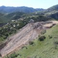
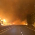
There where major fires burning North of here at the time. This Nullschool wind map below shows the wind direction and particulate overlay at the time. The green dot on the map marks the approximate location of the detection.
Here are three possibilities that have been put forward for the source of this local spike in background.
A. Fire North of here.
B. Cosmic ray burst.
C. Hot particle passing by the sensor.
Monthly and yearly average charts from 2007 to 2018.
http://sccc.org.au/yearly-average-background-radiation-levels
Disclaimer: This is an amateur volunteer run service. Human error can provide incorrect information, and equipment malfunction can produce false readings. Do not rely on, or take action upon information presented on this web site, without further research.
Southern Hemisphere October 2018 Background Level Report
Station location
http://sccc.org.au/monitoring/Australian-Map.jpg
This short animation of Northern and Southern Hemisphere air circulation, shows why we can get detections so far south.
October 2018 day average background chart,
Caloundra October month average, year comparisons.
2018 13% above pre-Fukushima average
2017 32% above pre-Fukushima average
2016 22% above pre-Fukushima average
2015 12% above pre-Fukushima average
2014 14% above pre-Fukushima average
2013 25% above pre-Fukushima average
2012 19% above pre-Fukushima average
Monthly and yearly average charts from 2007 to 2018.
Disclaimer: This is an amateur volunteer run service. Human error can provide incorrect information, and equipment malfunction can produce false readings. Do not rely on, or take action upon information presented on this web site, without further research.
« 1 2 3 4 5 6 7 8 9 10 11 12 13 14 15 16 17 18 19 20 21 22 23 24 25 26 27 28 29 30 31 32 33 34 35 36 37 38 39 40 41 42 43 44View All»


Recent Comments